Why a Ridge Can Guide a River
Why a ridge can guide a river becomes clear when you trace the watershed, read the slopes and follow how rain and snowmelt gather into streams.
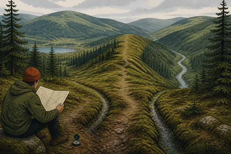
At a damp saddle between two northern hills, a walker finds a shallow groove on either side of the path. Water is not running in either one, but wet moss follows each dip away from the crest. This is where the shape of the ground explains why a ridge can guide a river: the ridge separates slopes, and the slopes lead towards different low points.
Imagine a hypothetical walk across a wooded upland after rain. A hiker has a paper topographic map, a compass and a simple question: which side of the ridge feeds the stream in the valley? There is no dramatic gorge or neatly drawn boundary. Instead, the hiker reads the high and low ground, then checks it against small features shaped by runoff.
A ridge divides the ground into falling sides
A ridge is a line of higher land, sometimes narrow and sometimes broad. Rain landing near its crest can fall on either side. Gravity draws water downhill; the ridge does not pull or steer it. Its influence comes from the slopes and hollows that begin around it.
A drainage divide separates land that drains towards different watercourses. A ridge commonly forms part of that divide, but the two terms are not interchangeable in every landscape. A divide can cross a broad plateau, a saddle or a gentle rise rather than follow a sharp crest. On a map, it marks the boundary between drainage basins, not necessarily a dramatic feature visible from a path.
In the invented walk, the eastern slope falls towards a narrow valley, while the western slope descends into a wider basin. The ground gives the first clue about where water can go, but small flats, bedrock, peat and old channels can complicate its route.
Contour lines reveal the likely route downhill
On a topographic map, contour lines join points at the same elevation. Lines close together indicate a steeper slope than lines spaced farther apart. Where contours bend into a valley, their V-shaped tips usually point uphill; where they bulge around a ridge, the higher ground lies towards the crest. These shapes help show where water is likely to collect and continue downhill.
The hiker compares the map with the land rather than treating a printed line as a promise of a visible stream. A blue line may mark a mapped watercourse, while an unmarked hollow may carry runoff only after rain or snowmelt. A mapped stream can also be hidden by vegetation or run beneath gravel. The map represents terrain and recorded features at a particular scale; it cannot show every wet patch.
On the eastern side of the hypothetical ridge, contours converge into a shallow notch and open towards a valley. On the western side, a separate notch leads towards the basin. The hiker marks both on the map and checks which way the V-shaped contours point. That reading suggests separate catchments, though the boundary is better understood as a zone than as a razor-thin line.
Water gathers in hollows before it becomes a river
Runoff can begin as a thin sheet over soil, rock or vegetation. As it moves downhill, small irregularities concentrate it into rills and then into channels. Those channels join larger ones, and their combined flow may become a stream. A river is the accumulated result of pathways converging through a basin.
On the walk, the hiker finds a damp groove beneath spruce trees. It runs towards the eastern notch, but no water moves through it. Farther down, the groove meets a broader hollow with stones and flattened grasses. This suggests a route used by runoff, though a dry channel may be intermittent, seasonal or inactive for long periods.
Ground cover affects what can be seen. Moss and peat can hold water near the surface; coarse gravel may let it seep below; exposed rock can send it across a slope. Fallen branches, animal tracks and old drainage channels can redirect flow locally without changing the larger pattern of water moving from high ground towards low ground.
What can interrupt the apparent watershed?
A ridge is a useful guide, not an absolute account of where every drop will travel. Water can cross a low divide through a ditch, culvert or canal built by people. Underground drainage through cracks or permeable rock can also carry water towards a basin that is not obvious from surface contours. Glacial deposits and landslides may leave depressions or barriers that alter local drainage.
In the invented walk, a forestry track crosses the eastern hollow. A ditch beside the track collects water and sends it along the road rather than down the natural slope. Farther down, a culvert returns the flow to the hollow. From above, the route looked continuous; on the ground, a human-made channel briefly changes it.
That detour matters when interpreting wet ground. A puddle beside a track may reflect road drainage, not the natural position of the watershed. A stream crossing a low area may also be channelled or diverted. The broad catchment can still be inferred from the surrounding relief, while the immediate flow path has been modified.
How do you read a watershed on a map?
Do streams always begin at the highest point?
No. A stream may begin at a spring, wetland, lake outlet or hollow partway down a slope. Its watershed surrounds the land that drains towards it, and can include both high ground and lower slopes.
Can a ridge belong to more than one watershed?
Yes. A ridge can form the shared boundary between neighbouring basins, with water falling on opposite sides feeding different drainage networks. Where divides meet, several basins may converge around a high point or saddle, so the ridge belongs to the boundaries of those watersheds rather than being contained by just one.
Why might a mapped stream be dry?
Some channels flow only after sustained rain or during snowmelt; others may be underground or obscured by vegetation. Map scale and local conditions also affect whether a channel is shown clearly.
Can water cross a watershed divide?
Surface water can be redirected by ditches, culverts and other constructed channels. Underground drainage may also cross the boundary inferred from surface contours, so compare the map with visible ground features rather than assuming the divide controls every local flow.
The walk checks the map against the land
In the hypothetical situation, the hiker follows the eastern hollow downhill, keeping clear of soft ground. The damp groove becomes a trickle where shallow rills meet. Lower down, the channel joins a small stream in the valley. Its position matches the broad drainage pattern on the map, although the track ditch has altered one short section.
The hiker then looks back towards the crest. The western hollow falls away in the opposite direction and leads towards the separate basin. A low saddle between the hollows offers a crossing point, but it does not necessarily mark the exact watershed boundary. The ground around it is broad and gently sloping, so the route of runoff depends partly on where it lands and what lies beneath the surface.
The result is a chain of observable clues: the crest separates slopes, contours show the hollows, small channels gather runoff, and the larger valley receives the joined flow. The ridge guides the river indirectly by shaping the terrain that directs water towards the basin.
Read the divide as a zone, not a line
For a walker, the useful question is not only “Where is the ridge?” but “Which way does the ground fall from here, and where do its hollows lead?” On a map, trace the contours from the crest into neighbouring valleys. On the ground, look for saddles, wet grooves, rills and channels, while allowing for seasonal flow or changes made by a track.
In the invented walk, that approach lets the hiker identify the eastern stream’s likely catchment without claiming that every wet patch belongs to it. It also explains why a narrow high crest can separate rivers whose routes eventually diverge. The ridge forms part of the drainage boundary; the water’s route emerges from the slopes and hollows below it.
When reading why a ridge can guide a river, keep the map’s scale in view. A watershed may look like a crisp line on paper while appearing as a broad, subtle divide on the land. Follow the ground from the high point into the nearest hollows, then check whether they converge towards the mapped watercourse.