How Polaris Became a Northern Wayfinding Reference
Learn how Polaris became a northern wayfinding reference, how to identify it, and when its position helps orient a map without replacing a compass.
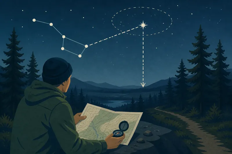
On a clear night, someone stops beside a spruce-lined track and asks which way is north. Polaris, the North Star, offers a useful clue: it sits close to the north celestial pole, though it is not exactly on it. That makes Polaris a northern wayfinding reference, not a perfect celestial pin.
Polaris became useful through its place in the turning sky
As Earth rotates, stars appear to move across the night sky. In the Northern Hemisphere, their paths seem to circle a point near Polaris. Because Polaris lies close to that point, it appears nearly still while other stars trace wider arcs.
This pattern made Polaris useful to people who could recognise it and see enough of the northern sky. It offered a repeatable clue for finding north, which could then be checked against coastlines, tracks, landmarks or a map. Its value came from its position, not exceptional brightness.
The relationship is not exact or timeless. Polaris is offset from the celestial pole, so it traces a small circle during the night; over much longer periods, the pole’s apparent position shifts as Earth’s axis changes orientation. Those details matter for precise astronomy and for interpreting older accounts of the sky, while ordinary wayfinding calls for an approximate direction.
Polaris points towards north, but not to a precise bearing
Imagine extending a line from Polaris down to the horizon. The point where it meets the horizon is approximately north. In a forest, among mountains or under a low cloud ceiling, that point may be hidden, so the star can indicate a direction without giving you a visible landmark to follow.
Polaris’s height above the horizon also gives a broad indication of latitude. It appears higher as an observer travels farther north, low near the equator, and close to overhead at the North Pole. Estimating that height by eye is only a rough clue, not a substitute for a map or navigation instrument.
Polaris is below the horizon in the Southern Hemisphere. Travellers there use other celestial references, including the Southern Cross as a broad indicator of south; recognising and applying those patterns requires a clear enough view of the relevant stars.
The Big Dipper can lead you to Polaris
When the Big Dipper, part of Ursa Major, is visible, use the two stars on the outer edge of its bowl as pointers. Extend a line through them towards Polaris. The Big Dipper changes position through the night and across the seasons, so follow the relationship between the pointer stars and Polaris rather than expecting one fixed picture.
The Little Dipper, or Ursa Minor, is centred around Polaris, but several of its stars are faint. Haze, nearby lighting, trees and buildings can make its outline difficult to see. A phone astronomy app can help identify a pattern; a printed star chart is a useful option if a device is unavailable or its battery is flat.
Say you are on an open track, and the Big Dipper’s bowl is visible while its handle is screened by trees. Identify the two pointer stars, extend their line to Polaris, then compare that direction with the north arrow on your paper map. The resulting check can help orient the map; if the pointer stars are obscured, stop relying on that method and use a compass or another known reference instead.
Use the star with a map and compass
Polaris can help you check which way is north, but it cannot identify a route, reveal longitude or show what lies between you and a destination. A topographic map shows named terrain and routes; a compass helps establish a bearing; landmarks connect the map to the ground. The star is one more clue, not a substitute for those tools.
Imagine a walker in a clearing who has lost sight of a marked path. They identify Polaris, use it to orient the map, and compare the mapped contours with a ridge they can see. If the ridge and the map do not agree, the useful result is uncertainty: the walker should check their location and references before choosing a direction, rather than forcing the match.
For a journey in unfamiliar or demanding terrain, carry a suitable map and compass and know how to use them. If a navigation error could have serious consequences, base decisions on reliable equipment and local conditions, not a star alone.
What readers ask about Polaris and wayfinding?
Does Polaris stay in the same place all night?
It appears nearly stationary because it lies close to the north celestial pole, but it traces a small circle as Earth rotates. For rough orientation, visibility and correct identification usually matter more than that small apparent motion.
Can Polaris show true north?
It indicates approximately true north because of its position near the celestial pole. It is not an exact bearing, so use a map and compass when precision matters.
Is Polaris the brightest star in the northern sky?
No. Other stars may appear brighter. Polaris is useful because of its position and its connection to recognisable star patterns, not because it dominates the sky.
Can Polaris be seen from anywhere on Earth?
No. It is visible from much of the Northern Hemisphere and lies below the horizon in the Southern Hemisphere. Near the equator it sits low in the north, where terrain, buildings or haze can block it.
When Polaris is hidden by cloud, daylight or terrain, do not infer north from a blank patch of sky. Use a map, compass or another known reference, and pause if poor visibility makes your direction uncertain. Polaris is a useful northern wayfinding reference when visible; checking it against the ground is what turns a sky clue into a sound decision.