The Weather Map Is Not a Picture of the Ground
A weather map gives the broad pattern, not the conditions at your feet. Learn to read terrain, exposure and cloud before choosing a northern route.
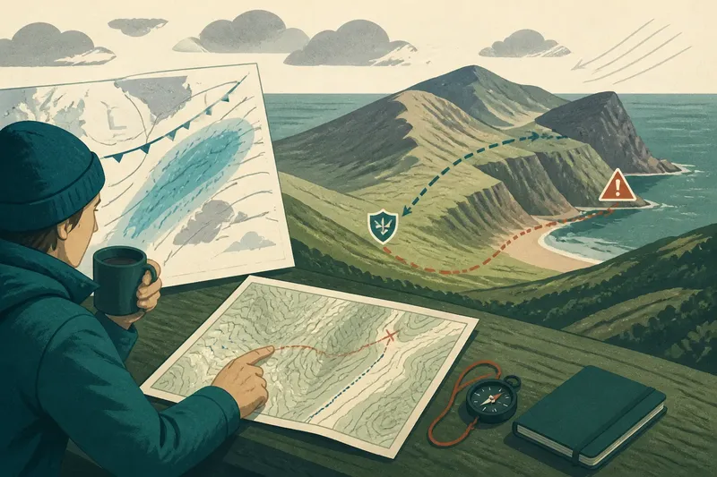
You check a weather map over breakfast: a pale patch covers the valley, a darker band sits offshore, and the forecast mentions wind. A weather map gives useful context, but it is not a picture of the ground. In northern country, a regional forecast can leave a sheltered bend, exposed headland or snow-filled hollow to tell a different local story.
Reading weather for a particular place means moving from the large pattern to the features that alter it. Start with the forecast, locate the terrain, then look for signs of how air, cloud and precipitation meet that terrain. This will not outguess the weather; it can help you avoid treating one symbol as a promise about every path beneath it.
Begin with the regional weather pattern
First identify what the forecast describes. A weather map may show a front, pressure pattern, precipitation area or wind direction across a broad region. A local forecast may narrow that down to a town or grid square, but neither necessarily describes a specific slope or shoreline.
Check the forecast period and the conditions it actually provides. Wind direction and strength, precipitation, temperature, cloud and visibility each matter differently to a route. A rain symbol does not say how far inland rain will reach, while a cloud icon does not tell you whether a ridge will be clear.
Read the pattern before zooming in. Note which way the wind is coming from, where precipitation is expected to move and whether conditions may change during your outing. The broad pattern is your starting point, not the answer.
Match the forecast to the terrain
Open a topographic map or an app such as OS Maps and trace the ground between your starting point and destination. Look for ridges, valleys, steep slopes, coastlines, broad plateaux and narrow passes. These features can expose a route to wind, shelter it, channel air through a gap or make conditions change over a short distance.
Compare the forecast wind direction with the shape of the land. A slope facing into the wind is more exposed than one behind a ridge. A valley may be sheltered in one section, then funnel air along its length; a pass can feel markedly windier than the lower ground on either side.
Also consider elevation and aspect. Higher ground is often more exposed, and a route that crosses a ridge may encounter cloud or wind absent below. The sunny side of a valley and its shaded side can differ in snow, dampness and visibility, even under the same regional forecast.
Imagine you plan to walk from a sheltered inlet to a headland, and the forecast calls for strong wind from the sea. Your OS Maps view shows a low ridge between the two. You mark the inlet path as sheltered, identify the headland as exposed, and decide to use a lower inland track instead if the ridge blocks your view of the coast; the expected result is a route that avoids committing to the exposed headland before you can assess conditions there.
Ask what the map cannot show
A weather map simplifies a moving atmosphere into symbols and broad areas. It cannot show every gust behind a rock, every fog bank in a hollow or the exact point where drizzle turns to snow. Those details depend on local terrain and changing conditions.
Cloud is particularly easy to misread. A clear forecast for a nearby settlement does not mean a high ridge will be clear, and low cloud can cling to higher ground while the valley remains open. If visibility matters for route-finding, consider how you would navigate if landmarks disappeared.
Precipitation can also be uneven. Wind-driven showers may strike one side of a hill and pass another by, while coastal weather can differ from conditions farther inland. The map indicates the larger area at risk; it does not draw the exact edge of each shower on the ground.
Check conditions again as you travel
Before setting out, compare the forecast with what you can see from a safe, sheltered place. Watch the cloud base, visibility, tree movement and the direction rain or snow is moving. These observations are clues, not a replacement for the forecast: a calm car park does not establish that the ridge above it is calm.
As you gain height or leave shelter, pause where it is safe and reassess. Notice whether cloud is lowering, whether wind is becoming harder to walk against, and whether the route ahead remains visible. If conditions change faster than your plan allows, choose a lower route, turn back or wait somewhere suitable rather than relying on the earlier map symbol.
Keep a navigation method that does not depend on phone reception. An offline map or paper map and compass can help you maintain your position when cloud obscures familiar features. For unfamiliar terrain, difficult conditions or a route with serious exposure, seek advice from a suitably qualified local professional and follow relevant safety guidance.
What should you do with a weather map?
Use the map to identify the broad pattern, then compare it with the route’s terrain and what you can safely observe. Before setting out, check these points; each result leads to a practical decision rather than a confident guess.
- Check the forecast time and location. If they cover your route and outing, use them as context; if not, find a more relevant forecast before deciding.
- Check the wind direction against ridges, coastlines and passes on a topographic map. If the route faces the wind or crosses a funnelled gap, choose a sheltered alternative; if it lies behind a ridge, still reassess before exposed ground.
- Check whether the route climbs onto high ground. If cloud or wind is forecast there, plan a lower route; if not, remember that higher terrain can still differ from a nearby settlement.
- Check forecast visibility against the route’s navigation demands. If cloud could hide landmarks, carry an offline map or paper map and compass and choose a route you can navigate; if you lack those skills or tools, postpone that route.
- Check what you can see from a safe sheltered place before starting. If cloud is lowering or visibility is poor, shorten the outing or wait; if conditions look clear, continue only while the route remains suitable.
- Check for a safe place to turn back or take a lower alternative. If one is available, mark it before departure; if none is available and the forecast is uncertain, choose a different route.
Answers to common weather map questions
Does a rain symbol mean rain everywhere in the marked area?
No. It signals a forecast for a broad area or time, not an identical shower over every hill and valley. Use it to anticipate possible precipitation, then allow for local variations in terrain and the movement of showers.
Can a nearby town forecast describe a mountain ridge?
It can provide useful context, but a town forecast may not reflect greater exposure, height or cloud on the ridge. Check the forecast’s location and detail, then consider how the route’s elevation and shape differ from the town.
Why can the wind feel stronger in a pass?
A gap between higher features can channel moving air, while surrounding slopes offer less shelter there. The regional wind direction helps you anticipate which parts of a route may be exposed, though the exact effect depends on the local shape of the land.
What if the forecast and what I see disagree?
Do not assume visible conditions will remain benign or that the map is irrelevant. Recheck the forecast and compare it with the route: if visibility, wind or precipitation makes travel difficult, change plans or turn back; if conditions are manageable, continue cautiously and reassess where it is safe.
Make the route decision from both scales
Before committing to the route, bring the regional forecast and terrain map together. Mark exposed sections, sheltered alternatives and places where cloud or poor visibility would make navigation harder. Decide in advance what change in conditions would prompt you to shorten the outing or turn back.
The useful question is not whether the weather map is right or wrong. It is what the map says about the wider pattern, and how the ground between you and your destination may alter it. Read that distinction carefully, and the map becomes a basis for judgement rather than a small coloured substitute for looking around.
For a northern weather map, the most useful detail may be the contour line beside the symbol: it hints at where the broad forecast meets the actual place you intend to walk.